The country-wide Framework Geological Model of Poland, which serves as the foundation for modern geological cartography, was developed nearly two decades after creation of the first spatial model of Poland's geological structure within the range of -500 to -6000 m above sea level (Piotrowska et al., 2005), which was the world's first 3D geological model to span an entire country. Given the significant advancements in information technology and the growth of digital data resources over the past 20 years, there was a clear need to update and reconstruct the model to a more advanced version. This update not only reflects the latest geological knowledge but also incorporates significant improvements in technical aspects.
The new model represents a substantial leap forward in both its level of detail and its spatial scope. It includes critical features such as faults, salt diapirs, and the tectonic structures of mountainous regions. A key innovation is the addition of a parametric grid, which greatly expands the model's potential applications, including facilitating more advanced calculations. In the context of geological 3D cartography in Poland, this updated model marks a significant milestone.
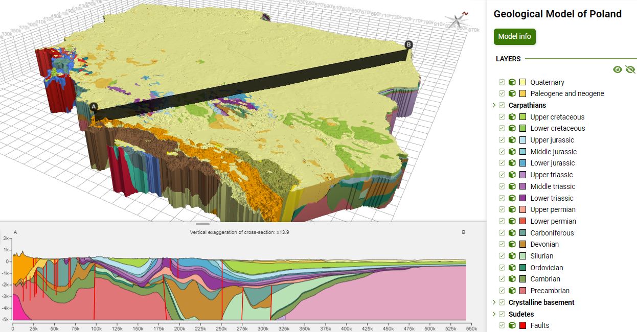
The 3D model, created between 2020 and 2023, visualizes the geological structure of Poland from 5 kilometers below sea level to the surface. It illustrates key chronostratigraphic units that make up the substrate of the Polish lowlands, as well as fundamental structural elements of the mountainous areas. The model also includes faults that highlight the most important tectonic events in the region's crustal evolution, including the faults of the Teisseyre-Tornquist Zone—one of Europe's most significant tectonic boundaries. This zone separates the East European Craton (which forms the northeastern part of Poland) from the basement of the West European Platform, which consists of various lithospheric plates assembled during multiple orogenies.
Additionally, the model provides detailed depictions of salt diapirs, primarily composed of Upper Permian rock salts, which are a distinctive feature of the Permian-Mesozoic structure throughout the Permian Basin. This basin stretches from Poland through Germany and Denmark to the North Sea. In the Carpathians, the model captures the most recent (few million years old) tectonic processes, showing the main tectonic nappes that were thrust during the Miocene over foredeep basin sediments. Lastly, in the Sudetes region, the model includes the Sudetes Mountains and the Fore-Sudetic Block, highlighting also the largest intrusions in the area.
Framework model of Poland has been commissioned by the Ministry of Climate and Environment and financed by the National Fund for Environmental Protection and Water Management. We thank SLB and Aspentech for, respectively, donating and providing academic licenses of Petrel (SLB) and Skua-Gocad (Aspentech) that allowed us to use state-of-the-art software tools to construct this model.
To present the 3D model in a web browser, it had to be generalized. Due to the necessary simplifications, discrepancies with the recognized geological structure may have arisen. Please report such cases by writing to geo3d@pgi.gov.pl
Browse the Framework model of Poland in Geo3D
Proposed citation of the model:
Małolepszy Z., Meissner, U., Szynkaruk E., (red.). 2023. Framework geological model of Poland. PGI-NRI, Warsaw, Poland