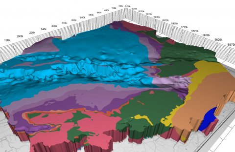
The legacy 3D model of geological structure of Poland presents the geological structure of Poland from depth of -6000 m above sea level to the surface. Three-dimensional solid models, geological cross-sections and blokdiagrams as well as spatial animations allow for analysis of deep geological structure. The model was implemented in two stages (from -6000 to -500 m above sea level and from -500 m above sea level to topo surface), using a variety of modeling tools. It was created as a simplified 3D model showing the solids of stratigraphic epochs through Quaternary, Tertiary, Cretaceous, Jurassic and Triassic as a part of Mesozoic, down to Permian and Paleozoic as a whole; and regional: Crystalline basement, Miocene deposits of the Carpathian Foredeep, Outer Carpathians and Inner Carpathians. The 3DGP model was created on the basis of geological maps at various scales from 1:50 000 to 1: 1 000 000 (surface, sub-quaternary, sub-cenozoic), geological horizontal section maps (Kotański, 1997), drill holes profiles, published and archived data (geological and geophysical) and information from Central Geological Database (CBDG) and from other existing PGI databases. The model, apart from the scientific aspect, has also practical and educational purpose. 3D models strongly influence the imagination of the recipient, presenting a complex geological structure in a very accessible and understandable way for a wider audience.
The described model has been simplified as a result of the technical limitations of the used digital tools tools in years 2003-2005. In addition, it presents the state-of-the-art of the regional geological structure from the beginning of the century and does not take into account many drill holes developed after the end of the project. All major faults have been used for modeling and they are visible in the shape of the layers. Unfortunately, due to technical constraints of the outdated digital model, we can not include faults as separate objects to display in Geo3D browser.
In 2024 Polish Geological Institute released new 3D framework geological model of Poland.
Read more on the first, lower part of the 3D geological model of Poland: PDF